Mookgophong - Naboomspruit Accommodation

Witgatboom Boskamp
Self Catering House, Cottage, Chalet Accommodation in Mookgophong - Naboomspruit
Waterberg
Witgatboom Bush Camp is a self catering getaway located on a private malaria-free Nature Reserve 11 km outside Mookgophong (Naboomspruit). The Bush Camp mainly caters for small groups, couples and families. (Accommodates up to 21 people). …see more for bookings / enquiries and info.

Zwahili Private Game Lodge & Spa
Game Reserve And Bush Lodge Accommodation in Modimolle - Nylstroom
33km from Mookgophong - Naboomspruit
Zwahili Game Lodge offers and an authentic bush lodge experience near Modimolle (Nylstroom) in the Limpopo province. Embrace a true African experience, luxurious rooms and elegant tented camps. Masterful cuisine, personal exclusive experience. …see more for bookings / enquiries and info.

7th Hole Golf Lodge
Bed & Breakfast Accommodation in Modimolle - Nylstroom
39km from Mookgophong - Naboomspruit
7th Hole Golf Lodge offers bed and breakfast accommodation and a self catering option in the Koro Creek Golf Estate near Modimolle (Nylstroom) in the heart of the Waterberg in Limpopo. Conveniently located within the bushveld Koro Creek Golf Estate. …see more for bookings / enquiries and info.

Klipkuile River Bush Camp
Self Catering House, Cottage, Chalet Accommodation in Sterkrivier
50km from Mookgophong - Naboomspruit
Klipkuile Bush Lodge offers self catering accommodation near Sterkrivier in the heart of the Waterberg bushveld in the Limpopo province. Accommodation comprises of one camp for ideally 2 to 13 people. Klipkuile translates as 'Rock Pools' and refers to... …see more for bookings / enquiries and info.

Kokoriba Guest Farm
Self Catering House, Cottage, Chalet Accommodation in Vaalwater
62km from Mookgophong - Naboomspruit
Kokoriba Guest Farm is an affordable and private guest farm situated in Vaalwater, only 12km out on the Melkrivier Road, less than two hours drive from Pretoria offering 2 self-catering units sleeping 6 and 10 people or B&B on request. …see more for bookings / enquiries and info.

Elements Private Golf Reserve Lodge 278
Self Catering House, Cottage, Chalet Accommodation in Bela-Bela - Warmbaths
66km from Mookgophong - Naboomspruit
Elements Private Golf Reserve Lodge 278 offers self catering accommodation in a golf estate near Bela-Bela in the Limpopo province. (Sleeps 4 adults). Set in the heart of the Bushveld, Elements Lodge No 278 is a privately owned Golf lodge... …see more for bookings / enquiries and info.

Elements Private Golf Reserve 104
Self Catering House, Cottage, Chalet Accommodation in Bela-Bela - Warmbaths
67km from Mookgophong - Naboomspruit
Elements 104 is a self catering apartment (sleeps 2) on a residential site overlooking the golf course at Elements Private Golf Reserve, in the heart of the Bushveld near Bela-Bela and offers quality accommodation for golfers and holidaymakers. …see more for bookings / enquiries and info.

Feeskraal Lodge
Game Reserve And Bush Lodge Accommodation in Bela-Bela - Warmbaths
69km from Mookgophong - Naboomspruit
Feeskraal Private Safari Lodge (sleeps 8) is a luscious Waterberg Getaway, situated on the Elandsfontein Private game reserve. The Farm Elandsfontein is a private game reserve adjacent to the majestic Mabalingwe big five nature reserve. …see more for bookings / enquiries and info.

Gecko Lodge and Cottage, Mabalingwe
Self Catering House, Cottage, Chalet Accommodation in Bela-Bela - Warmbaths
70km from Mookgophong - Naboomspruit
Gecko Lodge and Cottage (sleeps 14) is a very spacious, well equipped self catering holiday house ideally located in the Mabalingwe Game Reserve. The reserves offer private and guided game drives, spa facilities, restaurants 12500 hectares of African... …see more for bookings / enquiries and info.

Ngong Hill, Mabalingwe
Self Catering House, Cottage, Chalet Accommodation in Bela-Bela - Warmbaths
71km from Mookgophong - Naboomspruit
Ngong Hill Lodge is situated in a 13,000 hectare private nature reserve (Mabalingwe) supporting the big five. A beautiful home (sleeps 6) with breathtaking views of the Waterberg mountains. A game viewing vehicle can be hired, subject to availability... …see more for bookings / enquiries and info.

Hornbill Private Lodge
Self Catering House, Cottage, Chalet Accommodation in Bela-Bela - Warmbaths
76km from Mookgophong - Naboomspruit
Hornbill Private Lodge offers a self catering bushveld experience in the Mabalingwe Nature Reserve near Bela-Bela in Limpopo. Hornbill Private Lodge (sleeps 8) is a discreet private lodge situated within the 12,500 hectare big 5 game Mabalingwe Nature... …see more for bookings / enquiries and info.

Itaga View, Mabalingwe
Game Reserve And Bush Lodge Accommodation in Bela-Bela - Warmbaths
76km from Mookgophong - Naboomspruit
Itaga View offers the ultimate in self catering luxury, located in the Mabalingwe Nature Reserve near Bela-Bela in the Limpopo province. Itaga View is able to accommodate 14 guests in 4 bedrooms and an open loft all fitted with double and single beds... …see more for bookings / enquiries and info.

Kanaan Lodge, Mabalingwe Game Reserve
Game Reserve And Bush Lodge Accommodation in Bela-Bela - Warmbaths
76km from Mookgophong - Naboomspruit
Kanaan Lodge is located in Cyferfontein Mabalingwe near Bela-Bela in Limpopo and offers the epitome of luxury in the form of a self catering lodge. 4 bedrooms - sleeps 8 people. …see more for bookings / enquiries and info.

Impala Private Game Lodge
Game Reserve And Bush Lodge Accommodation in Bela-Bela - Warmbaths
76km from Mookgophong - Naboomspruit
Experience a true African sunset in the bush at Impala Private Game Lodge nestled in the heart of Mabalingwe Nature Reserve. The house sleeps 16 people on a self catering basis and is fully equipped. Enjoy breathtaking views from the deck. …see more for bookings / enquiries and info.

Shasha Lodge, Mabalingwe Game Reserve
Game Reserve And Bush Lodge Accommodation in Bela-Bela - Warmbaths
76km from Mookgophong - Naboomspruit
Shasha Lodge lies within the Cyferfontein camp of Mabalingwe Nature Reserve approximately 40kms from Bela-Bela in Limpopo. The lodge sleeps up to 20 guests (8 adults and up to 12 children). …see more for bookings / enquiries and info.

Siyanda Lodge Mabalingwe
Game Reserve And Bush Lodge Accommodation in Bela-Bela - Warmbaths
76km from Mookgophong - Naboomspruit
Siyanda Lodge is situated in the Mabalingwe Nature Reserve and offers accommodation for up to 10 guests in a beautiful lodge with a lovely forest feel and modern finishes. The lodge comprises two en-suite bedrooms plus two lofts - one being open-plan... …see more for bookings / enquiries and info.

Tholo Lodge, Mabalingwe Nature Reserve
Game Reserve And Bush Lodge Accommodation in Bela-Bela - Warmbaths
77km from Mookgophong - Naboomspruit
Tholo Lodge provides an authentic self catering bush lodge experience in the acclaimed Mabalingwe Nature Reserve near Bela-Bela in the Waterberg region of the Limpopo province. (Sleeps 8 adults + 4 children). This is an "Out of Africa" experience... …see more for bookings / enquiries and info.

25 Cyferfontein Mabalingwe
Self Catering House, Cottage, Chalet Accommodation in Bela-Bela - Warmbaths
78km from Mookgophong - Naboomspruit
25 Cyferfontein Mabalingwe provides self catering accommodation in the Mabalingwe Nature Reserve near Bela-Bela in the Limpopo province. Get really close to nature in this fully equipped luxury home (Sleeps 6 + 4 children), ideally situated... …see more for bookings / enquiries and info.

Bush Dream, Mabalingwe
Self Catering House, Cottage, Chalet Accommodation in Bela-Bela - Warmbaths
78km from Mookgophong - Naboomspruit
Bush Dream Mabalingwe is located in Mabula, 29 km from Feracare Wildlife Centre. Featuring free private parking, the chalet is in an area where guests can engage in activities such as hiking, cycling and ping pong. Mabalingwe Nature Reserve features... …see more for bookings / enquiries and info.

Mingwe Private Game Lodge
Game Reserve And Bush Lodge Accommodation in Bela-Bela - Warmbaths
78km from Mookgophong - Naboomspruit
Mingwe Private Game Lodge offers a self catering bush lodge experience in the Mabalingwe Nature Reserve near Bela-Bela in the Waterberg region of Limpopo. This self catering lodge has 4 en-suite luxury bedrooms (Suitable for 4 couples or 8 guests). …see more for bookings / enquiries and info.
Mookgophong - Naboomspruit
Mookgophong used to be known as Naboomspruit. Mookgophong is situated about 40km southwest of Mokopane, (Potgietersrus) at the foot of the Waterberg Mountains. This is a malaria free area.
The town of Mookophong started after a prospector named Adolph Erasmus discovered tin deposits in the area and miners rushed to the area. Later Erasmus also discovered platinum in the area and even more miners flocked to the town. Municipal status was awarded to the town of Mookophong in 1938.
Various crops are grown in the area. These include corn, nuts and citrus fruit. There are also cattle farms in the area.
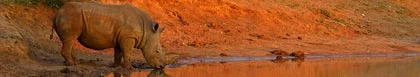
The Mookgophong area has numerous hot springs and tourists are well catered for. Accommodation in the area includes self-catering chalets and lodges. Nylvlei Nature Reserve and the Doorndraai Dam offer excellent opportunities for game and bird watching.
There are also private reserves in the Mookgophong area that offer game drives onsite, horse riding and guided nature trails. Other facilities are Internet access, conference facilities, golf, satellite TV and an onsite restaurant.